Digital Earth Africa Sandbox Newsletter - December 2021
Join us on our Learning Platform

Our new Learning Platform is available to assist with accessing and using our Sandbox. Register and enrol for free at https://learn.digitalearthafrica.org/ (separate account to Sandbox).
The ‘Intro to Sandbox’ course replaces the previous ‘6-week-course’. The course is self-paced and caters to a wide range of users. Beginners can gain confidence in using the Sandbox, while more experienced Sandbox users will enjoy trying interesting analysis methods.
Platform interface available in English and French
Course content available in English and French
Familiarise yourself with Earth observation analysis
Free certification available
New datasets - Fractional cover and more
We’ve recently created and indexed a range of new datasets for Sandbox users. One new service is the fractional cover that allows users to visualise areas of green and non-green vegetation, and bare soil.
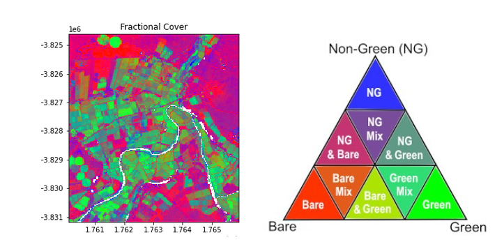
Fractional cover can be used to estimate land cover, land management practices, fuel load for wildfires, and vegetation studies. You can find out more about Fractional Cover in our interactive Dataset notebook:
Log in to the Sandbox → Datasets folder → Fractional_Cover.ipynb
or read more in the User Guide.
Find out about our other new continental-scale data:
Cropland extent maps for eastern, northern, western, southern & Sahel Africa
Digital Elevation Models - dem_cop_30, dem_cop_90, dem_srtm, dem_srtm_deriv
Monthly rainfall (CHIRPS model)
Land use and land cover - esa_worldcover, io_lulc
No code required: Wetlands analysis one click away

Use our new Wetlands Insight Tool to track water and ground cover composition over time. The drop-down menu and interactive map make it easy to select your area of interest and generate a graph - no coding experience required.

How to access: Log in to the Sandbox → Real_world_examples folder → Wetlands_insight_tool.ipynb
Interested in animations? Make GIFs with Frequently_used_code folder → Animated_timeseries.ipynb
Discover plant lifecycles with vegetation phenology: Real_world_examples folder → Phenolgy_optical.ipynb or Phenology_radar.ipynb
Rift Valley rising: monitoring water extent with the Sandbox

Rising waters in the Rift Valley Lakes are a significant concern, impacting urban areas, infrastructure, wildlife, and tourism. David Ongo from the Regional Centre for Mapping of Resources and Development (RCMRD) has used the Digital Earth Africa Sandbox to analyse water extent over time, focusing on Lake Baringo in Kenya.
Learn more about David’s work on Lake Baringo on our blog.
Try this yourself with our example notebook in the Sandbox: Real_world_examples → Water_extent_WOfS.ipynb or view the notebook on our User Guide (read-only).
Large Sandbox user survey
We are nearing the end of the first phase of testing 32 GB Sandbox instances (large environment). Digital Earth Africa would like to know more about your experience. Please answer this quick survey.
Forgotten your Sandbox login details?
Forgot your password? Reset it by clicking “Forgot your password?”. See detailed instructions here.
Forgot your username? Log a Helpdesk ticket here.
Feedback & enquiries
We’re here to help. Please submit your enquiry here.
Topic Participants
Cedric Jorand